About the River
The Yarkon River (in Arabic: “Nahr al-Auja”- العوجا- which means “The Meandering”) is the river with the highest past rate of flow among the coast’s streams, and the second in natural past rate of flow following the Jordan River.
The Yarkon is mentioned in the bible as part of the inheritance given to the Tribe of Dan (Joshua, 19): “ The seventh lot came out for the tribe of the people of Dan, according to their clans. And the territory of its inheritance included Zorah, Eshtaol, Ir-shemesh, Shaalabbin, Aijalon, Ithlah, Elon…Jehud, Bene-berak, Gath-rimmon, and Me-jarkon and Rakkon with the territory over against Joppa.”
The Yarkon River is a steady flowing river, in the past its stream was natural and today the water flowing through it is sourced by deliberate pumping. Like all rivers, it is a natural creation, a result of millions of years of rainfall and flows which carved flow streams on their way to the drainage basin, the sea. The Yarkon is a defined hydrologic unit and its processes are dynamic and ongoing.
The Yarkon River is the second largest river within the State of Israel, after the Jordan River, according to its past spring flow, and the largest of the coastal streams spilling to the Mediterranean sea. The Yarkon River is the drainage point for a basin of 1,800 square kilometers which includes its main streams, Kana Stream, Raba Stream, Shiloh Stream and the Ayalon River.
In the past, until the mid 1950’s, about 200 million cubic meters of stream water flowed in the Yarkon, which amounted to about 25,000 cubic meters of hourly flow. Following the construction of the “Yarkon-Negev Pipeline” and the seizure of spring water for the purpose of supplying water, the Yarkon, in effect, dried up and became a sewer channel carrying the sewage waste of the developing metropoline surrounding it.
Since the early 2000’s, small amounts of source/spring water have been supplied to the Yarkon from the Yarkon/Taninim Aquifer. Purified waste water has also been streamed into the Yarkon. As of 2021 about 16 million cubic meters of source water flow in the Yarkon per year, which amounts to about 1,800 cubic meters per hour, and about 17 million cubic meters of reclaimed water which amounts to about 2,000 cubic meters per hour.
In the past, the Yarkon provided a water source that could be pumped for the irrigation of citrus groves at a rate of a few million cubic meters per season. Today, the pumping of water directly from the Yarkon Stream for agricultural purposes has been confined to only about 1.5 million cubic meters per year.
The Yarkon Stream begins in the Nofarim Pool, which is located in the Mekorot HaYarkon area near the city of Rosh HaAyin at the origin of the Yarkon/Taninim Aquifer. The altitude in this area is about 17+ meters. The length of the stream, from the Nofarin Pool to the sea- 27.5 km. The aerial distance is about 15 km. The average slope is about 0.6 promil.
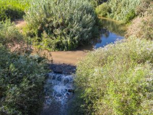
The Yarkon River stream is now divided into three different river sections in terms of the quality and type of water flowing in each section.
The upper section is about 7.5 kilometers long, and the flow consists of source water from the Yarkon Springs, in an hourly flow of about 1,800 cubic meters.
The middle section is about 16 kilometers long in which flow the upper section’s source water along with reclaimed water in varying degrees of purification, with an hourly flow of about 2,000 cubic meters.
The lower section of the Yarkon, about 4 kilometers long, is an estuary (or gulf) in which flow the source and reclaimed waters along with the water of the Mediterranean Sea which enters through the tidal regime.
The Yarkon River passes through 7 local authorities: Drom HaSharon Regional Council, Petah Tikva, Hod HaSharon, Ramat HaSharon, Bnei Brak, Ramat Gan and Tel Aviv-Yafo.
In the past, the Yarkon River constituted a natural obstacle, the historic Via Maris and the trade caravans had to divert from their course and pass around the Yarkon to the east of its origins. In ancient times a number of settlements existed along the Yarkon, including Tel Afek (Antipatris), Afek Tower, Tel Gerisa, Tel Qasile, Abattoir Hill, and Tel Qudadi at the Yarkon basin. All around the Yarkon area are archeological sites indicative of human activity such as irrigation facilities, bridges, dams and flour mills driven by the water power of the river.
The Yarkon River is a flooding river and in flooding events in the rainy season heavily flowing floods occur, with an overflow of hundreds of cubic meters of rainwater originating from the catchment basin. In flooding events, the water sometimes exceeds the flow section of the river, floodinע open and built-up areas surrounding the river, which constitute the Yarkon’s floodplain.
Along the Yarkon River and its banks exists a wide array of natural habitats, differing from one another in their physical conditions: the quality of water, its depth and the speed of its flow. These differences affect, among other things, the nature of the water’s flora and the animals inhabiting its different sections.