Along the Yarkon are many historical and archeological sites, reflecting a long history of settlement and events in the Yarkon River area.
The Yarkon River, as a unique natural resource in the landscape, has attracted social and economic activities from the beginning of the settlement period in the area. Below is a short and partial list of sites that have physical remnants in the field.
This site has a map of trails for hikers and cyclists, which can be printed at this link >>
This map contains all the sites to visit, and it will make it easier for you to find your way around.
Before leaving for the trip, please read the safety instructions carefully.
The Yarkon River Authority wishes you a pleasant and enjoyable trip!
Tzedek Tower
Mirabel
What Can You See? A complex of stone structures from the Ottoman period, built on the remains of a Crusader fortress. Migdal Tzedek is an archeological site from which it is possible to observe the area, in the area of a national park. Historical overview: The settlement has existed continuously throughout history due to its good control over the southern Sharon and the Yarkon Basin, and was part of the security system of the city of Antipatris, which was located near the springs.
During the Crusader period (12th century AD) the place gained importance and was called “Mirabel”, which means beautiful landscape. During the Ottoman period (19th century AD) an Arab man lived in the place, called Zadek al-Jama’ini, who engaged in the robbery and illegal collection of transit taxes on the main road (“Via Maris”) at the foot of the hill. The place is named after him, Majdal Tzadek, and in Hebrew: Migdal Tzedek.
Afek Antipatris National Park
What Can You See? The Ottoman fortress “Binar Bashi” is the most prominent relic of the place. The fortress was built on the house of a governor from the Canaanite period and next to it are the remains of the Roman city – Byzantine Antipatris (Afek).
Historical Overview: The settlement of Tel Afek has not ceased to exist for 5,000 years, from the beginning of the Early Bronze Age to the Ottoman period. In the late Roman period (2-4 centuries AD) Antipatris became the central city in the area and enjoyed its status as a major junction in the road system paved by Roman rule in Israel. Antipatris, together with Mirabel, controlled the Afek Passage, the Yarkon Basin and southern Sharon.
The Ottoman fortress at the top of the mound was built in 1571 by Sultan Salim II and was called “Binar Bashi”, meaning the head of the spring.
The Train Pillbox
What Can You See? A guard post on the Petah Tikva railway to Rosh HaAyin, which operated during the Arab Revolt (1936-1939 events). Historical overview: After the First World War, when Rosh HaAyin became a station on the Haifa-Quneitra railway line, the desire to facilitate the delivery of citrus goods straight to Egypt grew, and thus the idea was born to build a train from Petah Tikva to Rosh HaAyin.
The Arab uprising between the years 1936-1939 (the events of 1936-1939) raised the importance of the railway because other stations were blocked. It was during this period that the pillbox was erected, which served as a position for the railway guard against the Arab rioters. The guard was assigned to the “Railway Notary Corps.” The name Pill Box derives from the shape of the guard post reminiscent of a medicine box.
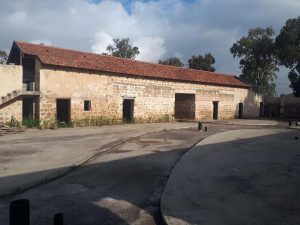
Kasser Farm
What Can You See? Remains of an agricultural farm with a well with Antillean water pumping facility and storage pool.
Historical Overview: The well and storage pool were built in 1878 by a Christian Arab merchant from Jaffa named Salim al-Qasr who bought the land and decided to establish an agricultural farm on it. In 1895 the farm was bought by Baron Rothschild who transferred it to the Petah Tikva Authority for agricultural experiments.
Today, the Kasser Farm is included in the area of the Mekorot Hayarkon National Park. The well is on the list of historic sites worthy of preservation prepared by the Council for the Preservation of Buildings and Settlement Sites
The Concrete House
What Can You See? A two-story concrete structure built in 1912 and used as a pump house by the “Palestine” irrigation company. The building has been preserved almost in its entirety and is reminiscent, in its external form, of the facade of the “Herzliya Gymnasium” – an old Palestine style.
Historical Review: The “Palestine” irrigation company was founded by Bezalel Yoffe with the aim of supplying water to the surrounding orchards. After his death, the house was sold to the Yarkon company, which is owned by the Israel Electric Corporation. The concrete house is a unique site in Israel and has great historical value as the first building in Israel to be built of concrete and as a factory that originally supplied water to orchards by modern means. The pumping house is located on the banks of the Yarkon River, near the Baptist village, and south of the Trans-Samaria Road (Road No. 5).
Site of “Yarkonim” settlement
What Can You See? Remains of the Yarkonim group’s attempt to settle on the banks of the Yarkon River in 1880.
Historical Review: After the founding of the Petah Tikva colony, several people from Petah Tikva and Jerusalem settled on the banks of the Yarkon. They chose the Yarkon as a settlement site due to its proximity to water sources.
The new settlers wanted to establish a settlement whose economy would be based on fishing and agriculture, but the place was plagued by fever. In the summer of the first year a fever caused many casualties among the settlers, and in the winter the Yarkon flooded the houses of the remaining when it overflowed and the settlers were forced to leave. The place commemorates the settlers with a large stone inscription.
Tel Qasile
What Can You See? An archeological mound dating back to a Philistine port city from the time of the Judges including temples and dwellings. At the foot of the area of temples and residences, there is a special pavilion with a display of the findings found in Tel Qasile. On the mound, are three layers of a Philistine settlement that were discovered during excavations conducted at the site. The floor of a Samaritan synagogue from the Byzantine period was also exposed.
Historical overview: The beginning of the settlement in Tel-Qasile during the period of the Judges with the establishment of a central port city. The Philistine city underwent three stages of development over 150 years, from its founding in 1150 BC until its destruction in a fire, apparently, by the armies of David in 980 BC.
During World War I, Tel Qasile served as a Turkish outpost against the British army advancing south toward the Yarkon.
The mound is located within the grounds of the Eretz Israel Museum in Ramat Aviv and received its name from fields of that name, which are located beyond the area of the mound.
Tel Kana
In the past, the mound was called “Almormer”, near Nahal Hadar and Nahal Kana. After an orchard was uprooted, it was seen on all sides fenced off with sabras and at its foot on the west side were ancient olive trees, planted at the beginning of the century by the orchard’s founders. Tel Kana is one of the chain of mounds along the Yarkon and joins Tel Qasile in Tel Aviv, Tel Grisha in Ramat Gan and Tel Afek in Rosh HaAyin. Although Tel Kana was no longer excavated and thoroughly investigated like the other mounds, it was surveyed several times. The history of the mound shows a settlement sequence from the days of the Canaanites to the days of the Return to Zion, as well as findings from the Phoenicians and Byzantine and Arab Romans.
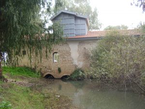
Al-Mir Mill
What Can You See? Remains of the first flour mill upstream, with three periods of construction: the Roman-Byzantine period, the Crusader or Mamluk period, and the Ottoman period.
Historical Overview: Al-Mir Mill is the first flour mill of the five mills that operated along the Yarkon and due to its proximity to Antipatris (Afek) is probably also the oldest. Its Arabic name is “Ma’abar”, as the name of the Arab village in the place. The origin of the name is probably in the fact that the walls of the mill served as a bridge for crossing the stream. The mill operated until the 1980s. The al-Mir mill is now located in the area of the Mekorot Hayarkon National Park.
Abu Rabah Mill
What Can You See? A flour mill built in the late 19th century by Sheikh Abu Rabah near an ancient mill that was destroyed. The southern mill building was restored in 2003.
Historical overview: In 1913, as part of improvements to the mill, two relatively modern turbines from Germany were installed, replacing the wooden wheels. In 1917, after the withdrawal of the Turks and the explosion of the Yarkon bridges, the value of the mill increased, as it was the only transit bridge over the Yarkon.
Between 1936 and 1948 the mill operated as the only one, thanks to its modern equipment and convenient access roads that led to it. During the War of Independence, the mill stopped operating and in 1959 its operation was finally stopped due to the establishment of the Yarkon-Negev project.
Faruhiya Mill
What You See? Remains of the diversion canal of a flour mill that operated near the village of Faruhiya and was operated by the slaves of the Bedouin tribe of Abu Kishk.
Historical Overview: The Faruhiya Mill is known to us only from maps and inscriptions due to its demolition to the foundation in the early 20th century. The Faruhiya Mill was used until the end of the 19th century and its demolition process was rapid: the people of Faruhiya used the mill’s stones to build houses, pave a road and for army needs in the First World War.
The mill site used to have a flour mill and bridge and now has an electrical switching station.
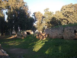
Al Hadar Mill (Ten Mills)
What Can You See? Al-Hadar Mill is the largest and most impressive mill of the Yarkon mills and possibly even in the whole of Israel. The only remains that can be seen today in the area are the western wall of the northern mill and a wall that formed part of the southern dam.
Historical Overview: Construction of the mill began as early as the Roman period. At the height of its activity, at least twenty pairs of millstones operated in the mill, but its name was given to it at a time when only ten pairs operated in it. The mill ceased to operate during World War I, when the Turks blew up the bridge and dam as they retreated.
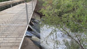
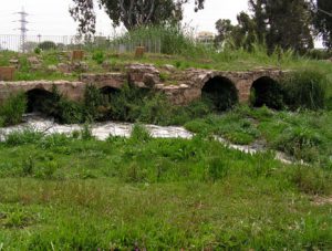
Jerisha Mill (Seven Mills)
What Can You See? Remains of a complex of three flour mills from the 19th century, located on top of earlier remains. At the site, a stone dam and a wooden bridge over a narrow waterway.
Historical overview: The origin of the name “Seven Mills” is the seven milling systems that operated in the western structure of the mill complex. The word “grinding” in the name of the place indicates the action of grinding in the place. The western mill operated continuously for as long as the Ottoman period, the other two mills were built in the 19th century. The complex operated until 1936.
Remains of an ancient dam served as a base for the recently built stone dam that allows crossing of the Yarkon.
The “Seven Mills” site is located in the area of Ganei Yehoshua Park. An article about the Seven Mills site, from Agan Hayarkon Magazine – Sites and Hiking Trails, published by the Society for the Protection of Nature and the company’s hiking youth groups.


 (2)")