Continuous Green Yarkon Blueprint
The plan for a green and continuous space in the Yarkon developed following the blueprint for the Yarkon completed in 1996, the blueprint for the Yarkon Basin currently being completed (2020) and statutory plans that formed the basis for significant urban developments in the area along the Yarkon to the Green Line.
To download a green and continuous space in the Yarkon – Summary Report>
The basic idea is to create means of control and monitoring of what is happening in the Yarkon area to help maintain it, without charging a fee for entry.
Activities in the Yarkon area include traffic along the banks on dirt roads and on footpaths, off-road motorcycles, ATVs, vehicles of various types and sometimes also horses. The “Israel Trail” also runs along the stream. Over time, many areas have been established where the public stays for different periods of time, some have become permanent and some are casual and in some places there are parties during which the organizers close areas and do not allow free access to the public. These incidents are accompanied by noise nuisance, the accumulation of large amounts of trash that is not removed from the site and road damage.
The River Authority has examined several possible models to address the challenges. Tours and meetings were held, including board and council meetings and the conclusion reached by the authority was that the “Springs Valley” model could be used as a basis for formulating an administrative concept for the open space along the Yarkon, with the necessary adjustments.
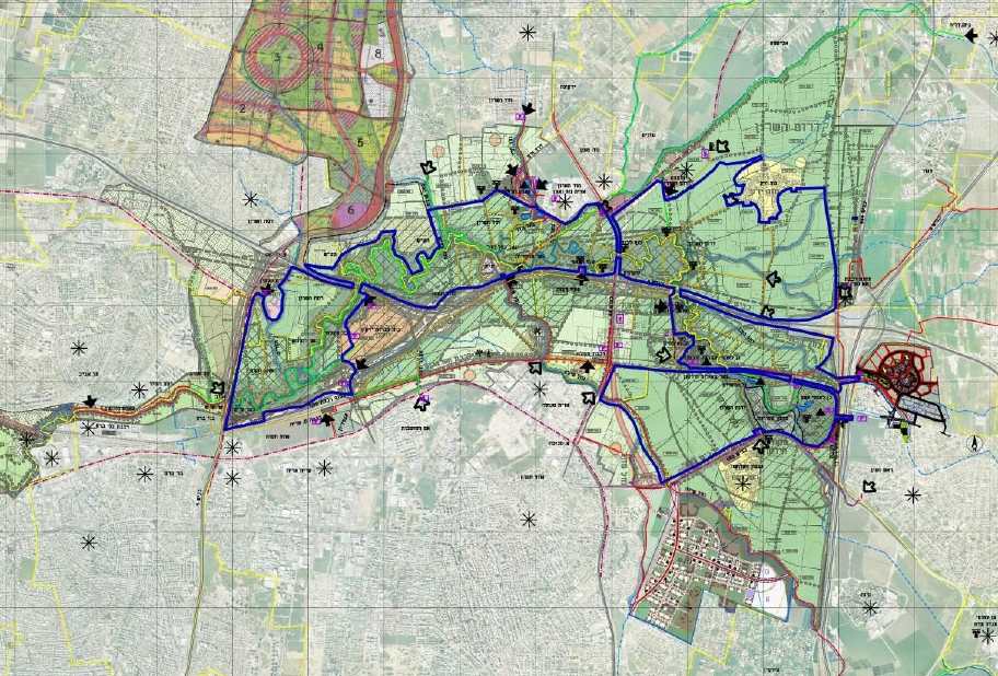
The project in question extends from Highway 4 in the west to Highway 6 in the east within the boundaries of DOP 10/3. This area borders and is near a number of central cities, local and regional councils including Bnei Brak, Ramat Hasharon, Petah Tikva, Rosh HaAyin, Kfar Kassem, Kfar Bara, Jaljulia, Drom HaSharon Regional Council and Hod HaSharon. Many resources have been invested in the construction, development and maintenance of the area that stretches along the Yarkon from the estuary in the west to Road 4 in the east. This area includes parks, trails and bike paths, leisure and tourism sites, educational and public buildings and heritage sites. Archeology is a major attraction for the area’s residents, hikers and tourists. This plan is a “natural continuation” of the area that was developed in the past and will prepare the area from Road 4 in the west to Road 6 in the east in a total area of about 13,300 d, including links – “green fingers” to the cities and towns that surround it. Even today, the need to develop the space in question can be seen as many visitors crowd the area, especially on weekends.
Work on the plan document is expected to be completed during 2020.
The purpose of the program: Creating a green and continuous space in the Yarkon Basin and a system for its management and implementation
Creating a central open public space in the Gush Dan metropolitan area
Preservation of the eco-hydrology and ecology of the space that constitutes a central ecological axis in the basin
Creating a base and space for promoting diverse environmental plans, including commuter routes for cyclists – east-west and north-south
Preservation and encouragement of linking leisure and recreation centers, archeology sites, heritage and tourism
Creating an infrastructure for cooperation between stakeholders and establishing joint administration
Contributing to the area’s economy